Inspection In Progress
Land at Sector 150
Noida, Uttar Pradesh • #VAL-10284
Step 3 of 7: Boundary & GPS
Next: Site Evidence →
Active High Precision
±4 m Accuracy
28.439120° N, 77.488210° E
Offline Ready
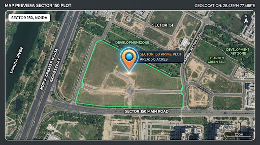
Vector Roadmap View Mode
Polygon Closed • 6 Vertices Connected
Mapped Parcel
Registry: 12,500 sq.ft
Grid: WGS84
Boundary Closed
Area & Registry Comparison
Mapped Area
12,430
sq. ft.
Official Registry
12,500
sq. ft.
Variance
-70 sq.ft
-0.56%
High Accuracy Match (<1% variance). Field GPS polygon aligns closely with deed. Does not alter official registry title records.
Existing Boundary Reference
Valuation Officer: RK (Emp #904)
Verify existing verified boundary polygon or commit updated revision for multi-year property re-evaluation.
P1
28.439180° N, 77.487920° E
GPS (±3m)
10:48 AM
P2
28.439410° N, 77.488340° E
GPS (±4m)
10:51 AM
P3
28.439250° N, 77.488780° E
GPS (±4m)
10:54 AM
P4
28.438890° N, 77.488710° E
GPS (±3m)
10:57 AM
P5
28.438810° N, 77.488230° E
Manual Drag
10:59 AM
P6
28.438960° N, 77.487910° E
GPS (±4m)
11:02 AM
Clear Mapped Boundary?
This will reset all 6 GPS vertices and polygon calculations. This action cannot be reversed.